LADOS: Aerial Imagery Dataset for Oil Spills Detection, Classification and Localization Using Semantic Segmentation
Overview
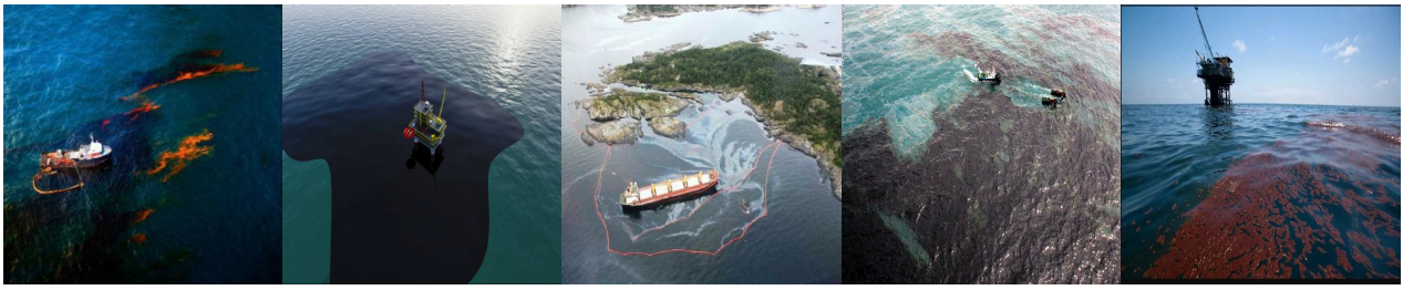
Oil spills on the water surface pose a significant environmental hazard, underscoring the critical need for developing Artificial Intelligence (AI) detection methods. Utilizing Unmanned Aerial Vehicles (UAVs) can significantly improve the efficiency of oil spill detection at early stages, reducing environmental damage; however, there is a lack of training datasets in the domain. To tackle the above challenges, we introduce LADOS, an aeriaL imAgery Dataset for Oil Spill detection, classification, and localization using semantic segmentation approaches dedicated to the visible spectrum. One of the key innovations of LADOS is the inclusion of the emulsion and sheen oil products that address a critical gap in marine pollution datasets. LADOS contains 3388 RGB images gathered from online sources, including six classes “Oil”, “Emulsion”, “Sheen”, “Ship”, “Oil-platform”, and “Background” related to oil spill incidents of inland, coastal, and offshore water surfaces.
Description
LADOS dataset consists of 3388 images and 6462 annotated instances (polygons) from five unique classes (in addition to the “Background”) with an average of 1.9 instances per image. The following table depicts the distribution of images and instances per class among the training, validation, and testing sets, following the commonly used split ratio of 70–20–10%.
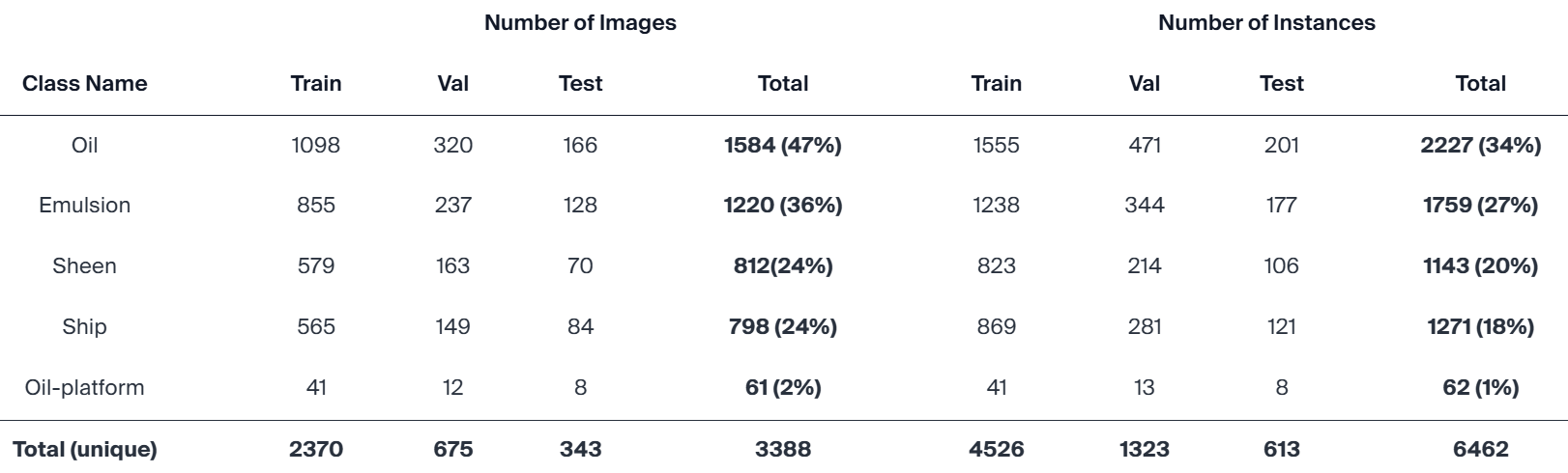
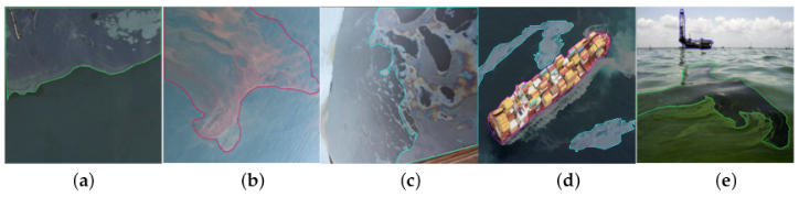
Particularly, the training set includes 2370 images with 4526 annotated instances, the validation set includes 675 images with 1323 annotated instances, and the testing set includes 343 images with 613 annotated instances. The majority of the images (3158), along with their masks have a resolution equal to 640×640 pixels, and the rest (230) equal to 416×416 pixels. Indicative samples of the generated dataset and the corresponding annotated masks are illustrated in the figure below. From left to right, representative samples of LADOS images and their annotations are illustrated: (a) “Oil”, (b) “Emulsion”, (c) “Sheen”, (d) “Oil” and “Ship”, and (e) “Oil” and “Oil-platform”.
Additional details regarding the dataset curation process as well as our experimental results and conclusions cab be found in our research paper “LADOS: Aerial Imagery Dataset for Oil Spill Detection, Classification, and Localization Using Semantic Segmentation”, which was published in the MDPI Data.
Download
The LADOS dataset is publicly available from the Roboflow repository and here.
Citation
If you find our work useful in your research, please cite both our paper and the dataset repository:
Gkountakos, K., Melitou, M., Ioannidis, K., Demestichas, K., Vrochidis, S., & Kompatsiaris, I. (2025). LADOS: Aerial Imagery Dataset for Oil Spill Detection, Classification, and Localization Using Semantic Segmentation. Data, 10(7), 117. https://doi.org/10.3390/data10070117
Gkountakos, K. LADOS Dataset. Roboflow Universe; Roboflow: 2025. Available online: https://universe.roboflow.com/konstantinos-gkountakos/lados
License
The dataset is licensed under CC BY 4.0.
Contact
Konstantinos Gkountakos: gountakos@iti.gr
Konstantinos Ioannidis: kioannid@iti.gr
Stefanos Vrochidis: stefanos@iti.gr
Related Projects