A New Era of Urban Resilience and Efficiency
Overview
Leveraging High-Value Datasets for Urban Innovation in Europe
High-value datasets are essential public sector data resources that provide significant social, environmental, and economic advantages. In accordance with EU regulations, these datasets are made freely available in machine-readable formats, ensuring they are accessible for use in developing innovative public services throughout Europe.
Across the continent, several European cities are demonstrating how these datasets can be used to address a range of urban challenges – including wildfires, road maintenance, emergency response, and sustainable mobility. This overview highlights how cities and regions such as Attica (Greece), Herne (Germany), Napoli (Italy), and Porto (Portugal) are transforming open data into practical solutions that enhance everyday life for their citizens.
Attica: Protecting Against Wildfires
Each summer, the Attica region in Greece faces an increasing threat from wildfires. Traditionally, fire monitoring depended on static risk evaluations and limited involvement from the public. However, with the integration of open data and advanced digital tools, local authorities have launched a near real-time alert digital service. This service utilizes geolocated social media posts, air quality data derived from S-5P TROPOMI satellite products and historical burned area maps for validation purposes.
This shift from a top-down to a citizen-driven approach marks a significant transformation. Data quality scores in Attica have risen from 34–39% to over 85–90%, reflecting a substantial improvement in both the accuracy and responsiveness of fire detection. The integration of nitrogen dioxide level data and social media activity has further reduced false alarms and enabled faster intervention when fires are detected.
The high-value datasets and other related data sources used in Attica are accessible via the European Data Portal.
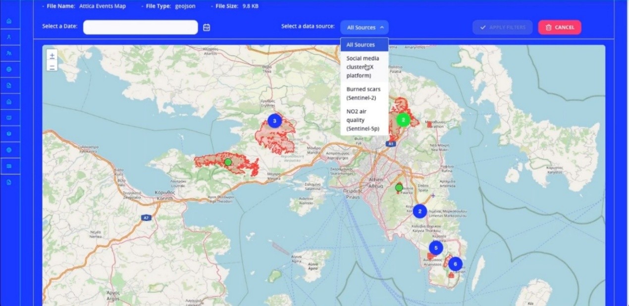
The wildfire alert digital service combines near real-time satellite scans, nitrogen dioxide data and social media posts to accurately identify and respond to fire events swiftly.
From Pilot Programs to Policy Change: Lessons for Cities
The four pilot projects discussed are part of the EU-funded BeOpen project, which aims to help cities utilize high-value datasets to address their specific urban challenges. Lydia Montandon, Community Outreach Coordinator at the FIWARE Foundation and a member of the BeOpen consortium, emphasized that digital tools and improved data quality can significantly enhance public service delivery. By making high-value datasets more accessible and reliable, the BeOpen project has empowered participating cities to improve their decision-making processes and service provision, offering a replicable model for other cities to adopt.
These cases illustrate the power of open and enhanced public data to foster smarter, more efficient decision-making in European cities and regions. Whether it is safeguarding communities from wildfires, predicting floods, managing urban traffic, or advancing green infrastructure, the reuse of high-value datasets is bolstering urban resilience and supporting the delivery of better public services across Europe.
To gain deeper insights into how European cities are transforming open data into actionable solutions, you can explore the details of the BeOpen project.
Methodology
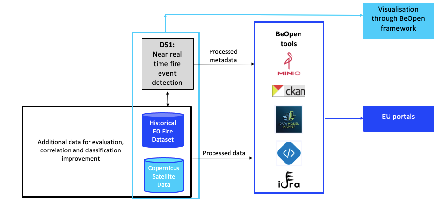
The High-Value Datasets used in the Attica pilot include enriched metadata derived from geolocated social media posts, predicted fire danger levels, burned scars, and Sentinel data. These datasets have been processed and managed using tools and functionalities provided by the BeOpen Framework, which serves as the backbone for data integration, management, and analysis.
The BeOpen Framework has been instrumental in ensuring effective data management, harmonization, and visualization. MinIO, supported by the framework, has been utilized as the primary storage solution, enabling efficient management of large datasets such as JSON files and shapefiles. BeOpen CKAN was employed to facilitate API accessibility for the Attica use case, ensuring seamless interaction with datasets. Furthermore, BeOpen CKAN has been federated with IDRA, creating a unified access point for discovering and accessing open datasets from diverse sources, enhancing interoperability and accessibility across platforms. The Data Model Mapper has been also used to transform and align the datasets to standardized formats, enabling their seamless insertion into the Orion Context Broker. Finally, Metadata quality has also been used by integrating the Metadata Quality Validator tool ensuring the datasets’ metadata adhere to high standards of reliability and usability. These tools collectively enhance the capacity of the Attica Digital Service to provide actionable insights for wildfire detection and monitoring.
Following the harmonization of the high-value datasets, the Near Real-Time Fire Event Detection Digital Service processes these inputs to identify wildfire incidents by detecting abnormal patterns across multiple data streams. It combines Earth Observation data with non-EO information, such as geolocated posts from platform X, using a late-fusion approach to improve detection accuracy. Visualization and dissemination are provided through the BeOpen Framework, which offers interactive maps and dashboards for exploring detected events and related indicators.
Dataset
The high value datasets include multi-source data critical for wildfire management, covering historical fire events, social media fire-related activity, predicted fire danger levels, and satellite measurements of air pollutants. These datasets provide comprehensive insights for detection, analysis, and response to wildfire events. The datasets are publicly accessible via the links below.
| Dataset Name | Description |
| Historical Fires Dataset | Wildfires (burned scars) occurred between 2019 and 2021 in Attica region, Greece.
https://data.europa.eu/data/datasets/attica-historical_fires?locale=en |
| Social Media Events related to Fires | Social media posts linked to identified fire events within the Attica region during the period of 2019 to 2021. These events are grouped into clusters based in event anomaly detection analysis of social media posts.
https://data.europa.eu/data/datasets/attica-social-media-events-related-to-fires?locale=en |
| Social media Posts related to fires | Fire-related posts from X social media platform including Tweet ID, Tweet URL, metadata produced from CERTH processing (i.e., timestamp, location extracted from text, links to related images, fire danger level, relevance score) in the Attica region during the period of 2019 to 2021.
https://data.europa.eu/data/datasets/attica-social-media-posts-related-to-fires?locale=en |
| Predicted Fire Danger Levels Using EFFIS Data | Predicted fire danger levels for the areas of Athens. Predictions were made using an MLP model trained on embeddings generated by SatCLIP and based on fire danger data from the European Forest Fire Information System (EFFIS)
https://data.europa.eu/data/datasets/attica-predicted-fire-danger-levels-using-effis-data?locale=en |
| Copernicus Data Space Ecosystem Satellite Data | Sentinel-5 measurements of NO₂ air quality anomalies from 2019 to 2021 within the Attica region.
https://data.europa.eu/data/datasets/attica-no2-air-quality?locale=en |
The dataset is publicly accessible via the links listed below.
• Link 1
• Link 2
Citation
If you find our work useful in your research, please cite both our paper and the dataset repository:
Evgenia Valla, Anastasia Moumtzidou, Mariza Kaskara, Stella Girtsou, Ilias Gialampoukidis, Stefanos Vrochidis, Charalampos Kontoes, and Ioannis Kompatsiaris “Wildfire event detection using social media and Earth observation data: a use case for Attica, Greece”, Proc. SPIE 13816, Eleventh International Conference on Remote Sensing and Geoinformation of the Environment (RSCy2025), 138161U (19 September 2025); https://doi.org/10.1117/12.3072927
Original source:
https://data.europa.eu/en/publications/datastories/new-era-urban-resilience-and-efficiency.
License:
Creative Commons Attribution 4.0 International (CC BY 4.0)
Contact:
Evgenia Valla: evg.valla@iti.gr
Anastasia Moumtzidou: moumtzid@iti.gr
Ilias Gialampoukidis: heliasgj@iti.gr
Stefanos Vrochidis: stefanos@iti.gr
Related Projects:
![]()